
THE SHIFTING CURRENT: HOW CLIMATE, POWER, AND LAWS ARE REDEFINING THE NILE
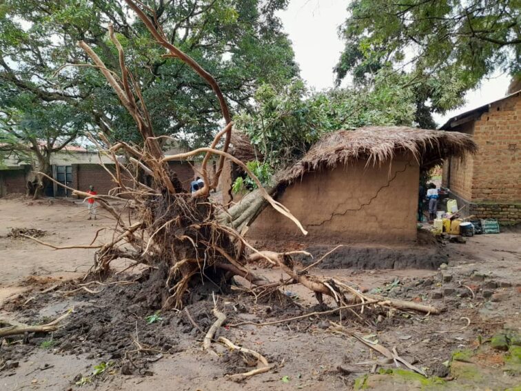
For communities along the Nile, the river is not an abstraction in an international treaty. It is a source of food, water, transport, energy and income. Photo//Dramadri Federick
By Dramadri Federick
Arua City
The Dry Bank and the Farmer’s Dilemma
Standing on the muddy, baked banks of the River Nile in Madi-Okollo District, northern Uganda, and Simon Onzima watches the brown water flow silently northward toward the distant Mediterranean. To geography scholars, international diplomats, and geopolitical analysts, the Nile is a grand, sweeping feature spanning eleven countries, thousands of kilometers, and centuries of contested hydro-politics. To Onzima, a smallholder farmer engaged in rain-dependent agriculture, the river is measured in far more practical, immediate terms as it is a source of household drinking water, sustaining his modest herd of livestock, and supports local fishermen who supply the Major district markets of Rhino Camp and Matangacia every morning.
In recent years, prolonged dry spells and erratic weather patterns have made seasonal rainfall increasingly unreliable across the West Nile sub-region. Fields that once yielded predictable harvests of simism, cassava, maize, and sorghum now suffer under scorched soils. For Onzima, the river flowing just a few hundred meters from his homestead represents the ultimate safety net, a potential, reliable source for small-scale irrigation that could protect his family’s crops from total failure.
“When the rains fail, we look to the river. If we cannot draw water to grow our food, how are our families supposed to live? The river is right here in front of us.” Simon Onzima, Farmer, Madi-Okollo District
Yet, the water Onzima gazes upon is bound by a complex web of international legal agreements, political tensions, and historical claims that reach back into the early twentieth century. Beyond his small plot of land, the Nile is central to one of Africa’s longest-running transboundary resource disputes. Upstream communities like Uganda, South Sudan, and Ethiopia among others find themselves asking a fundamental question of whether the colonial-era agreements signed nearly a century ago adequately govern a river basin where populations have exploded, national economies have expanded, climate realities have intensified, and local development needs have dramatically shifted.
At Obongi where the River Overflows It’s Limits
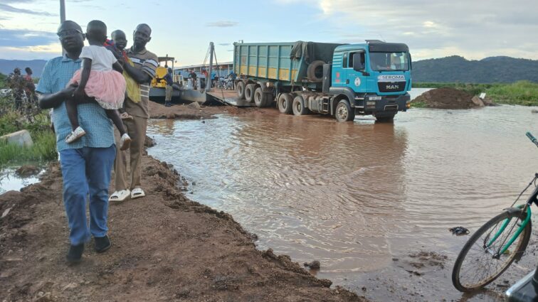
Families been rescued from the threats of flooding at Nile River buffers in Obongi district. Photo// Dramadri Federick
Following the river downstream into Obongi Town Council about 551 kilometers (342 miles) from the Source of the Nile in Jinja, and a drive of about 10 hours by car, the environmental challenge flips on its head: the problem here shifts from a lack of water access to uncontained, devastating flooding. Across northern Uganda, shifting hydrological dynamics and severe, localized weather events present immediate, hazardous challenges for urban planning and municipal management, pushing the river directly into public spaces, roads, and daily commercial markets.
The human toll of these swelling, unpredictable waters is felt immediately along the shoreline by local business operators, market vendors, and mothers managing household health under increasingly difficult circumstances.
Night Rukia Zam a resident of Kilman Village in Obongi Town Council and one of the business women who vends food in a local hotel at the Obongi Ferry Landing site says even if it is dry season the water floods making it difficult for planning. “Water comes and goes … we fail to get customers selling in a flooded area. We don’t know what to do, our shelters we constructed for selling food have all been submerged,”
Whereas for Aisha Inyaa a 50 year old grandmother of seven grandchildren and a farmer in Town East Village under Obongi Town council the situation is worrying as cases of sickness has risen in the area as house have been flooded into the river while access to education has equally become difficult for the learners as their Obongi town council Primary school is also submerged.
“Flooding contributes to children contracting waterborne diseases due to lack of clean water. Buffer zones are displaced.” Aisha Inyaa, farmer, Obongi
As these rising floodwaters repeatedly submerge vital civic infrastructure, local administrative authorities have been forced into a reactive stance. The river has gradually swallowed up roads, sanitation systems, and public buildings, turning routine seasonal rises into permanent displacement risks.
Saidi Makosa Sebbi, Principal Town Clerk of Obongi Town Council, emphasizes that these climate-driven impacts now mandate a complete restructuring and physical relocation of the entire urban center to higher ground.
“Implementing our physical development plan requires UGX 146 billion to relocate essential public infrastructure to safer ground.” Saidi Makosa Sebbi, Principal Town Clerk, Obongi Town Council.
This massive emergency relocation initiative is not merely theoretical; it involves moving the core administrative and social organs of the district. The plan encompasses relocating Obongi Health Centre IV, the bustling Obongi Main Market, Obongi Town Primary School, the Police Station and Barracks, and the Town Council Headquarters.
Recognizing the urgency of the situation, local communities have stepped forward to donate 14 hectares of higher ground free of charge to ensure their public institutions remain functional and safe from the river’s rising reach.
Jinja — At the Source of the Nile
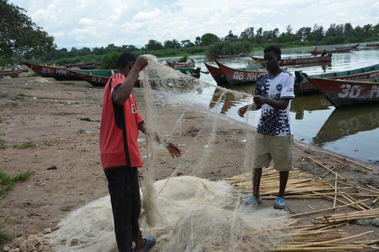
Fishermen preparing their fishing nets at the Source of the Nile in Jinja
Moving far upstream to Jinja, where Lake Victoria spills northward to feed the Victoria Nile, economic life, environmental advocacy, and national development priorities collide directly at the river’s point of origin.
In Jinja, local fishermen, fish traders, boat operators, and tourism businesses depend directly on steady, predictable river flows and clean water ecosystems. The river here is an economic engine for the Africa region and the entire world, supporting energy generation, commercial fisheries, and eco-tourism. However, rapid industrial expansion, land conversion, and urban runoff pose ongoing challenges to the river’s long-term health.
Environmental advocate Richard Andama Ferua emphasizes that “broad international treaty negotiations must not remain isolated in elite diplomatic circles; they must actively connect with practical, ground-level conservation work such as reforesting riverbanks, establishing protected buffer zones, and constructing effective municipal wastewater treatment systems. They must also apportion equal responsibility and utilization”.
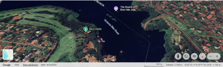
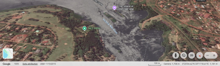
Satelite images of Nile River source showing the extent of buffer degradation between 2015 and 2025.
The environmental urgency at the source of the Nile is further highlighted by land degradation data across Uganda. Official mapping data from Uganda’s National Environment Management Authority (NEMA) reveals a stark landscape that out of Uganda’s total 33,762 square kilometers of wetland area, only 22,457.4 square kilometers (66.5%) remain intact. Over 11,305.1 square kilometers (33.5%) have suffered severe degradation or complete destruction due to agricultural expansion, urban encroachment, and unregulated industrial development.
During the launch of the Kalagala and Itanda Falls Conservation and Protection Project, The Permanent Secretary of Uganda’s Ministry of Water and Environment (MoWE), Dr. Alfred Okot Okidi, represented by Assistant Commissioner for Environment Maureen Anino, emphasized that protecting the River Nile is a matter of national energy security.
Dr. Okidi has repeatedly argued that upstream nations desperately require water access to expand regional energy production, build hydroelectric facilities, and scale up agricultural irrigation maintaining that lifting millions out of poverty requires utilizing national natural resources, but acknowledge that doing so successfully demands rigorous watershed conservation to safeguard downstream flow volume and quality.
The ministry announced the demarcation and restoration of over 2,400 kilometers of buffer zones along the River Nile. The official directive noted
“We must protect the Nile to safeguard major energy installations like Bujagali, Isimba, Karuma, and Nalubaale power stations, which depend entirely on the river’s flow.”
Volumetric Contribution Breakdown of Main Nile Tributaries
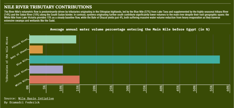
Graph showing Nile River Tributary Contributions
The River Nile’s volumetric flow is predominantly driven by tributaries originating in the Ethiopian highlands, led by the Blue Nile (57%) from Lake Tana and supplemented by the highly seasonal Atbara River (14%) and the Sobat River (10%) along the South Sudan border. In contrast, systems originating further south contribute significantly lower volumes to the main river despite their vast geographic spans: the White Nile from Lake Victoria provides 15% as a steady baseline flow, while the Bahr el Ghazal yields just 4%, both suffering massive water volume reduction from heavy evaporation as they traverse extensive swamps and wetlands like the Sudd.
The Cairo Terminal — A Drying Delta and Legal Standoff
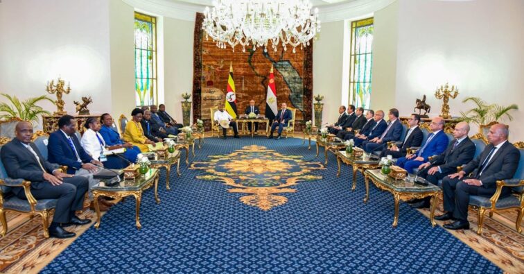
Uganda, Egypt agree on strategic partnership for the Nile, trade & regional stability- Courtesy Photo Uganda’s Ministry of Foreign Affairs.
Thousands of kilometers downstream from Jinja, through Madi-Okollo, and Obongi, the river’s long journey reaches its conclusion in Egypt, where the Nile empties through a vast, densely populated, and increasingly water-stressed delta into the Mediterranean Sea.
Here, in an arid landscape framed by desert and sustained almost entirely by a single river, trans-boundary water flow is not merely a component of economic planning, it is an absolute, existential matter of national survival.
Egypt has historically relied on treaties negotiated under British colonial administration in order to secure its downstream water supply against potential upstream diversion. On May 7, 1929, the Egyptian Government and Britain’s High Commissioner in Egypt exchanged formal legal notes establishing the Anglo-Egyptian Agreement. This document formally recognized Egypt’s “natural and historical rights” over the river’s waters and granted Cairo an explicit veto power over any upstream infrastructure projects such as dams, reservoirs, or large-scale irrigation schemes that could diminish downstream water volume.
Three decades later, Egypt and Sudan consolidated this legal regime by signing the bilateral 1959 Agreement for the Full Utilization of the Nile Waters. Entering into force in December 1959, this accord measured the Nile’s total average annual flow at Aswan and divided it entirely between the two downstream states. It allocated 55.5 billion cubic meters (BCM) annually to Egypt accounting for about 75% of the measured flow and 18.5 BCM to Sudan (roughly 25%), while setting aside 10 BCM for evaporation losses.
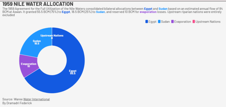
Graph showing 1959 Nile River Water Allocation to the Nile Basin Countries
This historical treaty granted 100% of the Nile’s volumetric flow exclusively to Egypt and Sudan and gave Egypt veto power over any upstream engineering projects. Upstream nations including Ethiopia, Uganda, Kenya, Tanzania, Rwanda, Burundi, South Sudan, and the Democratic Republic of the Congo were excluded and have long rejected these treaties as invalid colonial legacies.
This diplomatic tension reached the highest executive levels during bilateral state visits and summit discussions in Cairo between Ugandan President Yoweri Kaguta Museveni and Egyptian President Abdel Fattah El-Sisi. As outlined in the official 2026 Joint Communiqué, President Museveni advocated moving past rigid, colonial-era volumetric quotas. Instead, he called for a modern framework focused on shared regional needs developing integrated regional power grids, accelerating industrialization, constructing climate-resilient infrastructure, and executing joint watershed conservation programs across the entire basin. But Museveni also argued that the basin should move beyond an exclusive focus on historical water rights.
“Instead of limiting ourselves to historical rights, we should focus on the global needs of all Nile Basin countries.” Museveni stated
He identified prosperity, electricity, irrigation and clean drinking water as needs that should be addressed across the basin, arguing that scientific and fair methods could help countries achieve them.
In response, President El-Sisi reiterated Egypt’s absolute dependency on the river during joint media statements, emphasizing the stark geographic reality facing his nation, “Egypt has no other water source; we don’t have rainfall. The Nile is life for us.” Abdel Fattah El-Sisi, President of Egypt
This legal and diplomatic standoff is further exacerbated by global climate trends. The World Meteorological Organization’s (WMO) comprehensive State of Global Water Resources 2025 report reveals that 2025 recorded some of the lowest river discharge levels in 35 years. Below-normal flows affected 36 percent of global river basins, with the Nile Basin experiencing significant hydrological stress. Furthermore, WMO document metrics record a massive global glacier mass loss of 408 gigatonnes (equivalent to approximately 1.1 mm of global sea-level rise) and indicate that nearly 66 percent of monitored groundwater wells worldwide fell outside historical normal ranges.
WMO Secretary-General Celeste Saulo highlighted that depleted terrestrial water storage and declining groundwater tables severely reduce natural buffers against prolonged, multi-year droughts across major river basins, increasing the potential for resource competition.
Political Perspectives and Regional Dynamics.
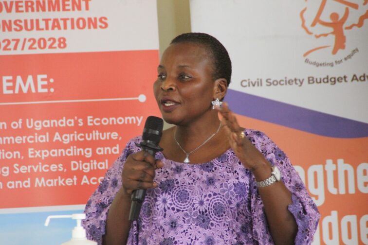
Hon. Akello Beatrice Akor, Minister of State for Northern Uganda says the Nile River discussions are on high gear. Photo// Dramadri Federick
The complex intersection of local climate vulnerability and high-level diplomacy is increasingly shaping policy debates within Uganda’s government and academic institutions. Officials and political analysts emphasize that addressing trans-boundary water management requires both institutional diplomacy and structured policy frameworks.
Highlighting the regional stakes, the Minister of State for Northern Uganda in the Office of the Prime Minister, Hon. Akello Beatrice Akor, noted that resolving the deep-seated disputes over river resources necessitates coordinated, international diplomatic engagement.
“The politics of the Nile River requires international intervention, but as of now, Cabinet is drafting a paper to engage other Nile Basin states.” Hon. Akello Beatrice Akor, Minister of State for Northern Uganda
This initiative underscores a growing recognition that national policies must align with broader regional agreements to prevent conflict and foster sustainable resource sharing.
Examining these political dynamics from an analytical standpoint, Policy Analyst Dr. Edward Kaweesi, Head of the Department of Political Science at Makerere University, points out the structural challenges inherent in transboundary river negotiations.
“The core challenge of Nile hydro-politics lies in balancing historical security paradigms with contemporary developmental realities. Downstream states view water flow as an existential security issue, whereas upstream states view it as an essential driver for economic transformation. True cooperation cannot occur through rigid bilateral quotas; it requires a shift toward cooperative governance where water is recognized as a shared regional asset rather than a zero-sum sovereign resource.” Dr. Edward Kaweesi, Head of Political Science, Makerere University.
The Seven-Point Path to Trans-boundary Cooperation.
The Seven-Point Path to Trans-boundary Cooperation outlines a holistic framework to resolve the historical tension between upstream development needs and downstream water security across the Nile Basin. To move beyond unilateral claims, the framework establishes core legal and operational guidelines, including replacing rigid historic quotas with equitable water allocation for all eleven riparian nations, institutionalizing safety standards to prevent downstream harm, and creating mandatory protocols for prior notification on major engineering projects. Additionally, it calls for coordinated, international funding to help vulnerable local communities adapt to climate change and build flood-resilient infrastructure.
Complementing these legal and operational safeguards, the strategy focuses on long-term ecological sustainability, scientific collaboration, and inclusive governance. It mandates the protection of vital headwaters and degraded wetlands to preserve natural flood filtration and flow regulation, supported by open, centralized data platforms like the Nile Basin Initiative to build mutual trust. Crucially, the plan relies on permanent, multilateral institutions where all member states participate as equals, ensuring civil society, local communities, women, and youth actively shape the future of shared water governance.
The Cooperative Framework Agreement (CFA)
The primary legal and institutional mechanism designed to operationalize this trans-boundary path is the Nile River Basin Cooperative Framework Agreement (CFA) which was rafted over years of intensive negotiation specifically to replace colonial-era legal arrangements, the CFA was opened for signature in Entebbe, Uganda, in 2010.
The agreement marked a historical milestone when it officially entered into force in October 2024, after achieving the required formal ratifications from six upstream nations of Uganda, Ethiopia, Rwanda, Tanzania, Burundi, and South Sudan. Unlike the restrictive bilateral agreement of 1959, the CFA establishes a multilateral, basin-wide legal structure representing all riparian nations. It formally enshrines the principle of equitable and reasonable utilization while eliminating historical downstream veto powers. In place of old legal structures, the CFA establishes a permanent, institutionalized Nile River Basin Commission (NRBC). Based in the region, the NRBC is tasked with overseeing joint water management, coordinating infrastructure development, facilitating prior notification procedures, and resolving disputes amicably.
This milestone resulted into the evidence-based management of the Nile Waters across borders, established the Nile Basin Initiative (NBI) that maintains the centralized Water Quality Database containing nearly 45,000 physico-chemical analyses contributed directly by member states. This database provides a shared scientific baseline to monitor agricultural runoff, municipal sewage contamination, industrial wastes, and catchment degradation across international borders.
Simultaneously, at the civil society level, the Nile Basin Discourse (NBD) under the leadership of Executive Board Chair Aynalem Ashebir Gebrehiwot works to ensure that high-level treaty implementation remains connected to ground-level reality. By amplifying the perspectives of rural farmers, local traders, women, and youth in NBI planning sessions, the NBD promotes equitable resource access, localized environmental stewardship, and sustainable trans-boundary peace-building.
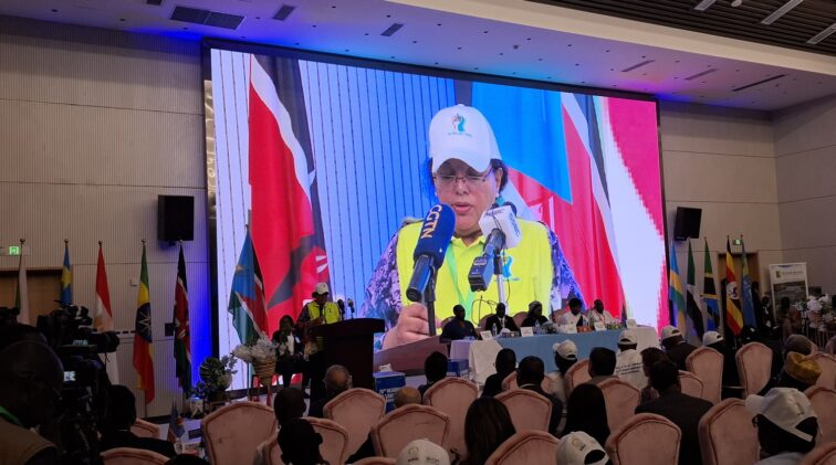
The NBD Chairperson Ms. Aynalm Ashebir delivers her remarks at the 20th Regional Nile Day Commemoration, Juba, Republic of South Sudan, 22 February 2026. Courtesy Photo:NBD
Shared Water, Shared Future
Back on the muddy bank in Madi-Okollo, the global debates over volumetric quotas, colonial vetoes, and ratification treaties fade against the immediate sound of moving water. For Simon Onzima, legal frameworks like the Cooperative Framework Agreement are not abstract exercises in diplomacy their true test lies in whether they enable a farmer to dip a pump into the river during a drought without fear of international conflict, whether they keep Obongi’s schools from disappearing beneath floodwaters, and whether they preserve the river for the generations to come.
As the Nile changes under the weight of climate shifts and expanding populations, its legal rules must change with it. Transforming the river from a source of geopolitical friction into a shared engine of climate resilience is no longer just a diplomatic preference it is the only way to ensure that the Nile continues to sustain both the nation downstream and the farmer standing beside its banks.
Managing Africa’s longest river in an era of accelerating climate change and rapid economic expansion requires moving beyond isolated national policies, historical grievances, and zero-sum legal claims. As population demands rise and hydrological patterns fluctuate, the long-term water security, economic prosperity, and environmental health of the entire Nile Basin rest upon a shared commitment to cooperative management, transparent scientific collaboration, and inclusive, multilateral governance.
Upcoming on 90.9 FM
Upcoming on 94.5 FM
Upcoming on 101.4 FM
Upcoming on 104.8 FM





Comments
This post currently has no comments.